Groundwater Conditions in Utah
Numbering System for Wells and Surface-Water Sites
Wells by Latitude and Longitude
The U.S. Geological Survey well-numbering system is based on the grid system of latitude and longitude. The system provides the geographic location of the well and a unique number for each site.
The number consists of 15 digits. The first six digits denote the degrees, minutes, and seconds of latitude, and the next seven digits denote degrees, minutes, and seconds of longitude; the last
two digits are a sequential number for wells within a 1-second grid. In the event that the latitude-longitude coordinates for more than one well are the same, a sequential number such as “01,” “02,”
and so forth, would be assigned.Even though the site number is based on latitude and longitude, it may not reflect the accurate location of the site. When error corrections or new technology locate
a site more accurately, latitude-longitude coordinates will change but the site number will not. In addition to the well number that is based on latitude and longitude for each well, another well
number is assigned based on the Cadastral system of land subdivision.
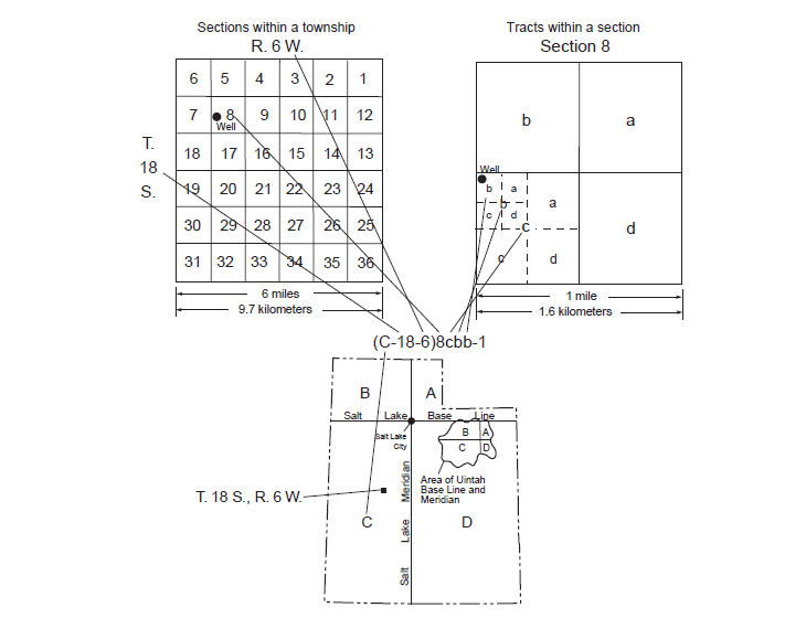
Wells by the Cadastral System of Land Subdivision
The well-numbering system used in Utah is based on the Cadastral system of land subdivision. The well-numbering system is familiar to most water users in Utah, and the well number shows the
location of the well by quadrant, township, range, section, and position within the section. Well numbers for most of the State are derived from the Salt Lake Base Line and Meridian. Well numbers
for wells located inside the area of the Uintah Base Line and Meridian are designated in the same manner as those based on theSalt Lake Base Line and Meridian, with the addition of a “U”
preceding the parentheses. Well numbers for wells located in half ranges will have an “R” preceding the parentheses.
Surface-Water Sites-Downstream Order and Station Number
Since October 1, 1950, hydrologic-station records in U.S. Geological Survey reports have been listed in order of downstream direction along the mainstem. All stations on atributary entering
upstream from a mainstem station are listed before that station. A station on a tributary entering between two mainstem stations is listed between those stations.
As an added means of identification, each hydrologic station and partial-record station has been assigned a station number. These station numbers are in the same downstream order used
in this report. In assigning a station number, no distinction is made between partial-record stations and other stations; therefore, the station number for a partial-record station indicates
downstream-order position in a list composed of both types of stations. Gaps are consecutive. The complete 8-digit (or 10-digit) number for each station such as 09004100, which appears just to the
left of the station name, includes a 2-digit part number “09” plus the6-digit (or 8-digit) downstream order number “004100.” In areas of high station density, an additional two digits may be added
to the station identification number to yield a 10-digit number. The stations are numbered in downstream order as described above between stations of consecutive 8-digit numbers.
Definition of Terms
Acre-foot - The quantity of water required to cover 1 acre to a depth of 1 foot - equal to 43,560 cubic feet or about 326,000 gallons or 1,233 cubic meters.
Average annual withdrawal - Calculated average from estimated withdrawals, rounded to the nearest thousand acre-feet.
Cumulative departure from average annual precipitation - A graph of the departure or difference between the average annual precipitation and the value of precipitation for each year,
plotted cumulatively. A cumulative plot is generated by adding the departure from average precipitation for the current year to the sum of departure values for all previous years in the period
of record. A positive departure, or greater-than-average precipitation, for a year results in a graph segment trending upward; a negative departure results in a graph segment trending downward.
A generally downward-trending graph for a period of years represents a period of generally less-than-average precipitation, which commonly causes and corresponds with declining water levels
in wells. Likewise, a generally upward-trending graph for a period of years represents a period of greater-than-average precipitation,which commonly causes and corresponds with rising water
levels in wells. However, increases or decreases in withdrawals of groundwater from wells also affect water levels and can change or eliminate the correlation between water levels in wells
and the graph of cumulative departure from average precipitation.
Land-surface datum (lsd) - A datum plane that is approximately at land surface at each groundwater observation well.
Precipitation - The total annual precipitation in inches, rounded to tenths of an inch. For selected locations, it is computed from monthly total precipitation (rain,sleet,hail,snow,etc.).
Data are supplied by the National Oceanic and Atmospheric Administration (NOAA) and the Western Regional Climate Center (WRCC). Data may be provisional and/or estimated when usedto compute annual
total and long-term average precipitation values.
Conversion Factors, Datums, and Water-Quality Units
| Multiply | By | To obtain |
| acre-foot | 1,233 | cubic meter |
| foot | 0.3048 | meter |
| gallon per minute | 0.06301 | liter per second |
| inch | 2.54 | centimeter |
| mile | 1.609 | kilometer |
| square mile | 2.59 | square kilometer |
Vertical coordinate information is referenced to the National Geodetic Vertical Datum of 1929 (NGVD 29). Horizontal coordinate information is referenced to the North American
Datum of 1983 (NAD 83).